Saturday, July 20, 2024

1000 Islands & 3 Cities

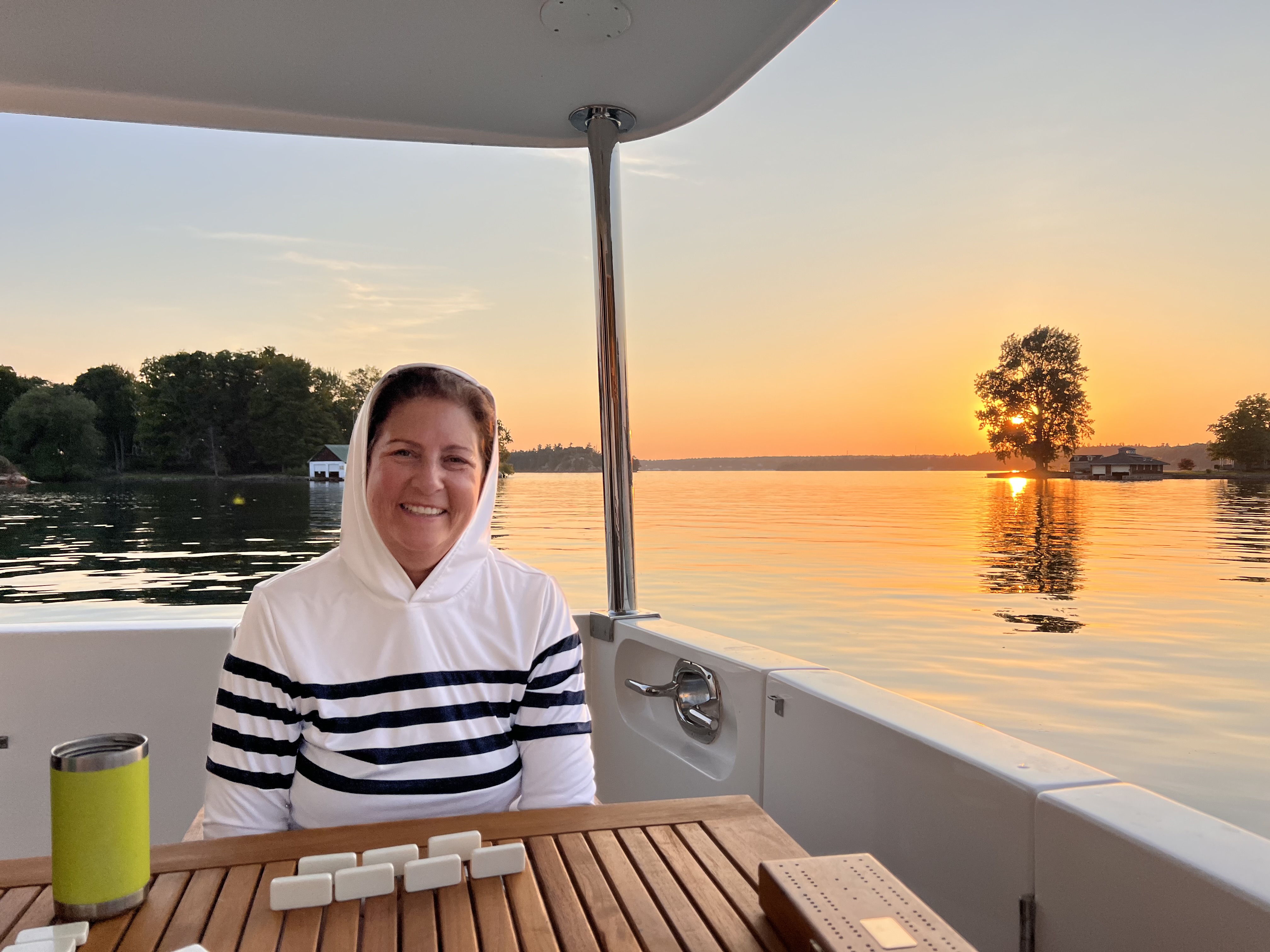
Sunset at anchor, at 1000 Islands. Post-dinner dominoes! A hood was necessary to show those mosquitos that I was in control.

LAY OF THE LAND
Lake Ontario is a border lake between the United States and Canada. The Easternmost side of Lake Ontario pours into the St. Lawrence River, also between Canada and the U.S. The St. Lawrence runs downhill (and Northeast), past Montreal, and at the 400-mile mark, Quebec City, all the way to the Atlantic Ocean. 

The head of the St. Lawrence River was a forty-mile-long region called 1000 Islands(1). I had never heard of it until a few weeks before we arrived. Yes, there were supposedly one thousand islands in the area, mostly small, and five large ones. They are populated with many waterfront homes that vacationers primarily use during the summer. 

We decided to hang out for a week and make it easy on ourselves by staying on the U.S. side. Then we would cross into Canada at a town called Kingston where we would go through customs and park the boat for a week. We took a vacation from the boat, again, and traveled via the Canadian railroad system to Montreal, Quebec City, and Ottawa. 

Our route was in red. This is the Northeast Part of Lake Ontario, if that helps you identify the area I referred to.


1000 ISLANDS


We left Oswego pretty early, I thought, but we were in the second set of boats to go through the lock (the thirty-first lock of this leg and our trip so far), the gateway to Lake Ontario. Our first take of Lake Ontario was a relief. The lake calmed down completely compared to the tremendous fetch we spied from the Fort Ontario hill three days before. Our second thought was how vast it was. We couldn't see land on the other side. And it was a lovely teal blue and noticeably clear fresh water. There was nothing brackish about this part of the trip. 

We first stopped at a 1000 Islands gateway town, Cape Vincent, which was a one-block-long town and had a free city dock.(2) We were shocked to be able to see ten feet down through the water.


We moved to the substantial gateway town, Clayton, NY, the next day. Not only was it a cute town to hang out with other Loopers and get supplies, but it also had a locally famous wooden boat museum

The homes we walked by seemed to be up to one hundred fifty years old. Most were a curious color of red brick with artistic black iron trim.(3)

We stayed at the marina for an extra night because there was much to do. 


Mike took an afternoon to join a fishing charter with some guys he met at the Clayton dock. He came home with some pike—a new taste for us. It's a good, mild-tasting fish.

There was a hum-dinger of a storm that night. I saw wind gusts of forty MPH. There was such a deluge of rain that I couldn't see the lightning strikes in the dark out our window. I only saw flashes. It reminded me that I was a long way from the Bay Area. Incidentally, Mike slept through the whole thing.


This area was famous for fast and stylish lake boats that New Yorkers used to speed to and from their tony island homes. The museum featured antique wooden racing boats and local boats owned by elite owners.

A shiny example of the exceptional antique boats in Clayton, NY. Can you imagine seeing boats like these whip around the islands in summer?


The other popular tourist stop was the Boldt "Castle" island. The small island supported an extravagant, three-story house, a family playhouse tower with a bowling alley, and a private power plant. The house was built in 1905. Rebuilding and refurbishing the structures was an ongoing process supported Boldt Castle with wedding venue fees and tourist entrance fees.  

Here was just the private power plant building from Boldt Castle. It was like something from a fairy tale. 

Our favorite stop in the 1000 Islands was at Grindstone Island. We anchored out for a night and dinghied in during the afternoon on a Friday. We quickly learned from a welcoming park ranger that there was a winery. This goal to try New York grown grapes led us on a three mile through swampy trails.

It was worth it to hike to Grindstone Winery. Helpful, hand-written signs pounded into the lush greenery, like the one next to Mike, showed us the way.


Great wine, warm hosts, and my first local delicacy--a wine slushy.(4)

Some island residents gathered at the winery for their weekly Friday night happy hour. It was fun to connect with them, comparing their community to ours at Decourcy Island. We were relieved that the apprentice winemaker was willing to give us an ATV-type ride back to the park border. We made it back to Sacagawea safe and sound with our new bottles of wine---and about twenty mosquito bites each!


We also enjoyed a couple of anchorages in between islands. These anchorages provided the first real opportunity to jump into the water right off Sacagawea's swim step. Just like in Cape Vincent, the water was clear and cool on the warm days we experienced that week. We noted that we needed some pool noodles!(5)

Mike’s drone captured this pic from above at one of our lovely anchorages. Note the posh house at the top of the pic with an arched bridge to a nearby islet. 


First swim ever off of Sacagawea in the 1000 Islands. Crystal clear water. A little cold, but doable. 


In every direction the 1000 Islands area was filled with rock islets like this one. The rocks often were striated with three colors: greenish on top, pink in the middle and blackish next to the water. Like Spumoni ice cream!

Here’s an example of one of the many, beautiful homes in the 1000 Islands:


Another notable feature of 1000 Islands are thoughtful, stylish boat houses. Here’s an example of another tasteful, large home and its boathouse:


After enough gunkholing, we puttered off to Kingston, but not without minor drama. About halfway there, Border Control stopped us. They asked us all the questions we were ready to answer for our planned customs check-in. The agents were friendly and made the stop easy. 


MONTREAL

In the morning, we left Sacagawea secured to the dock with about five lines and five fenders--just in case! We boarded Via Rail, the Canadian train system, for a three-hour ride, in comfort, to Montreal. Since we only planned to stay about twenty-four hours, we mostly stuck to touristy Vieux Montreal, the old neighborhood along the waterfront. 

Our view from the Via train as we approached I think Montreal.

At the bottom of Place Jacques Cartier, a pedestrian walkway lined with restaurants that leads downhill to the St. Lawrence River, we were impressed with a display of enlarged, turn-of-the-century black and white photos on the sides of vendor kiosks. These photos of the same area made it easy to imagine how Montrealeans used the area for a few hundred years as an open-air community center and market.


In the morning, before we departed, we decided to see how far we could walk to Montreal's hill, the Mont-Real ("royal mountain"!). Between racewalking to a subway and this uphill walk on a humid day, the excursion tuckered us out. With long days on the boat, traversing The Loop is not a great way to get your daily steps in--and we could feel it.

Climbing stairs in luscious Mount Royal Park. The greenery was so lovely. It was a weekend so it was  filled with fitness fans.

QUEBEC CITY

The journey to Quebec City(6) took another three-ish pleasant hours on a train. When we arrived after dark it was pouring rain. We decided to walk the short distance to our hotel. It turns out the hotel, and the entire historical district, were on a fairly steep hill. We survived the walk with only squishy tennis shoes and the bottom of our jeans soaked. Rain was forecast for the next two days. 

On the first morning, Mike came back to our room while I was getting ready with two new essential items: matching umbrellas printed with Canadian red maple leaves. My hero! Here in front of a random building in Quebec—all the buildings in the old city were like this one—colorful and worth a good look.

Even in the wet, the two to four-story buildings in the old city were each unique. And charming. And colorfully painted. There were flowery annuals in many window boxes and along the outdoor patio restaurants along the two tourist streets that were parallel and about four blocks apart. 

This requires a second look—this was a steep street and the window boxes were installed so that the tops were horizontal. The bottom of the boxes were parallel with the street. Cool, right?

Mike snapped this memorable view of Quebec City. Just gorgeous!

The next rainy day we spent at Quebec City's Museum of Civilization. I had never been to a museum like it. There were three main exhibits, each quite interesting. 


There was a special exhibit about gladiators in Rome. Ask me anything about gladiators now...like, did you know that different cadres of gladiators were differentiated by types of armor and weapons? And that the practice of gladiator shows petered out after a few hundred years as the quality of the gladiators decreased? 


Another richly detailed exhibit focused on the experience of aboriginal peoples of Canada. There were artifacts and descriptions of their traditional lifestyles. 

I appreciated this part of the aboriginal wing of the museum. This dramatic display showed the wide variety of snow shoes the peoples used. Their usage varied depending on the type of snow and terrain.

It was interesting yet sad to listen to recordings of people from various tribes who described how elements of their cultural identification were being lost. Other recordings described how their native cultures were evolving, just like all cultures evolve. Altogether, they demonstrated the pride and persistence of the various aboriginal peoples.


I enjoyed a History of Canada exhibit that paired descriptions of key Canadian historical dates with the chairs commonly used during the era. It also helped me to understand how the confederation of Canada was considered the inception of the country. I did not know this! 

What a unique way to learn about key dates in a country’s history. Visitors walked by a winding display of information cards marking important dates. An antique Canadian-red children’s chair associated with the era accompanied the time/card which described Canada’s inception. It worked for me.(7)  

And finally, there was an exhibit of what it meant to be a Québécois (the French term). I think it was designed for Quebec citizens to examine and perhaps strengthen what being Québécois meant to them. This reminded me that Canada is a relatively young country/democracy. 


We had two especially excellent meals (Italian and French-ish) in Quebec City. In between, we toured the fancy Fairmont Le Chateau Frontenac Hotel, the Citadelle of Quebec (which was a fort built starting in 1820 was steeped in military traditions) and the highlight: a private tour of the Governor General's mansion inside the Citadelle. We saw the luxurious formal meeting rooms and the exterior patio with an exclusive, commanding view of the St. Lawrence River. 

Me, casually strolling through the Governor General’s Mansion at the Citadelle in Quebec City. You can see the St. Lawrence River below and down a cliff to the right and the commanding view Northeast. It was a powerful place to build a Citadelle.

Mostly, we learned in a one-on-one format with our local tour guide about Canada's relationship with its sovereign, in England.(8)  

Outside of the Citadelle, which housed the Governor General’s mansion, had two of these sentries outside the gates. We watched a changing of the sentry. It was steeped in tradition and symbolism.

OTTAWA


Our last point of this trapezoidal trip was Ottawa. Mike, especially, was interested in seeing the seven "step" locks that allowed boats to move from the Ottawa River to the Rideau Canal.(9) We were there in the middle of a week, so few boats were going through. But we were impressed at the innovation of the locks and a little jealous of Loopers who could take their boats through it. Still, we were satisfied with our decision to forego the cruise there.

Mike snapped this pic of the Rideau Canal Locks from a bridge looking West. You are looking at the eight “step” locks that move boats 80 feet from Ottawa River to Rideau Canal. Also on the right is the fancy Fairmont Chateau Laurier hotel we stayed at.


Here, Mike checks out the Ottawa River, at it passes behind the government buildings and meets the Richelieu Canal. There were falls in the center and boats purposefully cruised around either side of the falls. It was a spectacular day for cloud watching as well.

The key buildings we couldn't miss in Ottawa were the national government buildings that house Parliament. These neo-gothic, behemoth buildings and towers were nothing like the neo-classical buildings in Washington D.C. We enjoyed looking at the exteriors on our sunny day in the city. 

At Parliment Hill in Ottawa. The architectural style was striking: “Gothic Revival.” Note the tall windows  with peaks and black ironwork. Totally unexpected.

In the morning, we managed to take a private tour of the temporary Parliament room (a large group canceled--we were the only ones left in the time slot). We learned about Parliament traditions related to opening ceremonies, passing bills to laws, and how they symbolically include the Sovereign. 


I found portraits of former prime ministers on the walls memorable for their intensity and relatability. Outside parliament, there was a hall filled with plaques imprinted with thousands of names: the members of each year's parliament. It was as if they were enshrined here, being accountable for Canada's choices and growth. 


TIME FOR THE TRENT-SEVERN WATERWAY


Next up: Trent-Severn Waterway. Unlike the 1000 Islands, you could say we've been anticipating the Trent-Severn Waterway for years--since we first learned of The Loop. Was it as beautiful and wonderful for boating as we had read? 


FOOTNOTES FOR FUN FACT FANS


(1) This is the home of 1000 Islands Dressing. To my surprise, I'd say the local restaurants played it down. I'm not too proud to admit that I love 1000 Islands Dressing.

(2) Many small towns along The Loop have free docks to encourage boaters to come to support the local economy. 

(3) ChatGPT says: "These homes often feature intricate detailing, such as ornate trim work, decorative brick patterns, and sometimes elements of Queen Anne or Colonial Revival styles, reflecting the prosperity and design preferences of their time."

(4) It was a port wine slushy. It's a unique blend of different ingredients, unknown to me. It's not just port wine and ice in an ICEE machine.

(5) We especially liked the fresh water swim because our shower's sump pump stopped working! We were able to order one and Mike, of course, installed it before too long. 

(6) The historic neighborhood of Quebec City is an UNESCO heritage site. All of it! Not just one building or fort.  

(7) For example, 1867, the year the British North America Act was signed, created the Dominion of Canada. Red is sort of national color for Canada; the red of the maple leaf of Canada’s flag.

(8) Canada has a constitutional democracy with a parliamentary system. They have a ceremonial head of state: the King of England. 

(9) The original motivation for building these locks was to move the British Navy during the War of 1812 (which Canada calls The War with the United States) through Upper Canada (a British colony). Ultimately, they never used it during a war. 


Monday, June 24, 2024

Empire


This was one of the Empire apples I ate while in New York. It’s motto, “The Empire State” started, possibly, by George Washington in a letter he wrote in 1785. “New York is the Seat of the empire,” wrote he.(1)


OPEN OCEAN

The New York section of our journey begins in New Jersey. Our cruise South, down the 55-mile-long Delaware Bay, took four hours and thirty minutes. So, one might say it is a large bay. We saw Delaware to the West and New Jersey to the East. (A new state!) The sea conditions were good, as predicted. It was an overcast day, making the water grey. Ho hum. 

On the New Jersey side of Delaware Bay, I saw what I believe was my first active nuclear power plant. It looked enormous among the flat landscape on this cloudy day.

Besides the nuclear power plant, our Delaware Bay leg was unremarkable, with an assortment of tankers and recreational boats, like us. 

Once we got through Delaware Bay and stopped for an overnight at Cape May, we carefully watched the conditions for transiting outside New Jersey in the Atlantic Ocean.(2) We planned two New Jersey stops: Atlantic City, (Google says a.k.a. "America's Playground"?!) and Massaquan, a small town with a protected marina. 

The weather from Cape May to Atlantic City was a good-enough "go" forecast the next day. So I donned my Relief Band(3) and we set out for the ocean. Poseidon delivered the conditions we expected. 

Heading out of Cape May at “O”-dark-hundred. Optimism abounds.

We stayed at a marina, popular with Loopers, and went into the adjacent casino once for breakfast.(4) We hung out at Atlantic City for three nights because the weather turned too windy to continue right away. 

We were relieved, frankly, that we got great, although overcast and cool weather as we pulled into Atlantic City. Here’s what it looked like, coming from the Atlantic Ocean. It was like the lower lip of a smile, with teeth missing. 

We had never been to Atlantic City, and I admit that it felt, frankly, a little creepy. The casinos were spread apart in three distinct neighborhoods. There was no strip, like there was in Las Vegas. We thought the new-looking wide boardwalk along the waterfront was nice for strolling. But, along much of it there were no restaurants or stores. There were empty lots along the boardwalk (many for sale) and spotted here and there within the town. 

As the wind died, we escaped from Atlantic City to the snug harbor of Manasquan for just one night.

NEW YORK CITY AND BURROUGHS

It was an exciting new day because our destination was finally New York City! To get there, we had a thirty-mile cruise in the ocean followed by about twenty miles through Lower Bay, south of Manhattan. 

As we moved North, our anticipation built at twenty miles out. There, skyscrapers started to grow over the horizon. However, it wasn't long before we discovered we were seeing the Brooklyn skyline, not Manhattan!  

After going under the Verrazano-Narrows Bridge, we sighted a tiny Statue of Liberty. Like the skyscrapers, it grew larger and larger.

The “we made it to New York” picture! It was feeling of victory. It was a thrill to see it just as the emigrants had on their trip to Ellis Island.(4) 

This is the story behind our iconic picture with our boat. There were a number of us Loopers who arrived at the Statue of Liberty at the same time. We tried to take pictures of each other. It was challenging because we were in the ferry lane and this part of the bay was filled with wakes, so everyone was bouncing side-to-side and up and down making it hard to maneuver. 

On night one, we anchored in a little bay behind the Statue of Liberty. For the next three days, we stayed at a marina next to the Statue at Liberty Landing Park in New Jersey. 

Our first night—having dinner with my cousin-once-removed, Florence Siegel, and husband Jerry. Florence is my family’s much-loved, always-lived-in-Manhattan contact. We had a theater-meal which starts at 4:30pm. Such a NYC thing, perhaps?  

The show we saw was “Hamilton.” We were there in the middle of the week and the theater was still packed. I was impressed with the ornate theater:

New York City was the jumping-off point for a week-long visit from our long-time friends, Meredith and John Radzins. It was an exciting place to kick this off because there were so many possibilities for tourists, like us.

I love this pic of Mike, me, Meredith and John because it exemplifies what I remember best of this leg. Being together was relaxing, fun and filled with spectacular views. We needed to take this short ferry ride from our marina to Manhattan. In the evening, we endured muggy subway rides back. 

While Meredith and John checked out the 9/11 Museum and Memorial, Mike and I rented bikes and crossed the Brooklyn bridge. I was eager to relive this—I biked the bridge about 10 years ago. This time, I realized that with the advent of electric bikes, this type of outing has changed. There are different lanes for bikes to increase the safety of pedestrians, so we shared narrowlanes with fast moving bikes and mopeds. This picture was our walk back, happily pushing our bikes in the pedestrian walkway.

We had our fill of the big city and pushed off North. We decided to go on the route-less-traveled up the East River and the Harlem River, which joined the Hudson River shortly after we spied the Yankee Stadium in The Bronx. It was a great decision because there was almost no boat traffic--but it was still scenic.

Here’s a video of the lovely intersection where the Harlem River meets the Hudson River:


HUDSON RIVER 

This week-long segment, on the Hudson River, was about one hundred and fifty miles long. 

One highlight was the cliffs along the shores and the copious, deciduous greenery.

Did you know much of the shore of the Hudson River was rocky cliffs? I did not.

Receiving a private tour of West Point (thank you to my cousin, Leda Mareth’s sister-in-law, Deborah Carter!) and seeing the Roosevelt home were also highlights. 

Here were the preserved chains used to secure the entire width of the Hudson River during the Revolutionary War to prevent the British Navy from proceeding up the Hudson. Cool and surprising history, because in modern times it seemed innovative. 

Thank you Deb, for the tour! I imagined this was the best view of the entire Hudson River Valley.

Mike and I trying to read one more sign in front of the Roosevelt home that we toured the next day.(6) Next, was FDR’s presidential library, the first presidential library. This was first ever visit to a presidential library. What a great way to learn history! 

Here was his desk from the White House, complete with funny little knickknacks. History is best when it’s humanized, IMHO. I could have read the fascinating, critical letters from key figures that Roosevelt posted in his library all day…but we had to move on…(7)

It surprised us that the Hudson River (like the Potomac River) had little recreational boat traffic. There weren't many places to go by boat along the shores and few good places to anchor. We learned first-hand that unlike the Southeast, waterways in New York (and the Northeast) have four seasons so they don't have enough boater business during the short summer season. So, good marinas and dockside restaurants are far and few.

At Albany, it was time to say goodbye to perfect guests Meredith and John. They asked to come back again, so it must have gone okay! It was time to think about the pros and cons of which way to go for our next segment. 


ERIE CANAL

We wanted to go to Montreal and possibly Quebec City, but via which route? Do we go North, to Lake Champlain and Richelieu River to Montreal? Or, do we go first West via the Erie Canal and Oswego Canal, into Lake Ontario, and down (which is Northeast) the St. Lawrence River? The Champlain route was reputed to be more scenic and it would save us eighty miles. However, there was a fixed bridge that was perhaps six inches above our flybridge arch.(8) We went the conservative route and made the left-hand turn at the Erie Canal. 

Someone had the bright idea to put a road-type sign at the “Y” where the Erie and Champlain Canals begin. You can’t miss the turn if you don’t use charts. We went left.

Depending on the route, Loopers go through 150 to 250 locks during the year. We had gone through locks in the 1990s in Seattle and during our Yonne River, France, trip in 2023, but we felt some trepidation about how it would go with Sacagawea. By the time we went through twenty-three locks in the Erie Canal and eight locks on the Oswego Canal during this segment, we had our equipment and routine worked out.(9)

In between locks, the Erie Canal was beautiful, much like the Yonne River a year ago. Lush, green, deciduous trees and bushes with white flowers lined both sides. It even had a few white swans.

There were small, two-hundred-year-old towns along the Erie Canal. Each town had its own story of industrial boom and bust. Each offered free docking along concrete walls, typically at a city park. It was a great way to meet other Loopers.

Getting ready for early morning transit in Amsterdam, NY. It says “Amsterdam” across the bridge. We tried to go alone through locks as much as possible to make it faster and easier. This is not always an option.

Returning to Sacagawea after after sunset—a walk along the Erie Canal.


A more interesting lock…greenery…old infrastructure…an active train overpass…and onward into the lock:

Looper friends behind us caught us in the act of chilling in our cockpit (aka back porch). This was along the free dock in Sylvan Beach, the jumping off point into Oneida Lake.

NIAGARA FALLS

Back at Albany, Mike determined that we needed new house batteries. So we left the boat and rented a car. We picked them up after a two-and-a-half-hour car drive West to Syracuse. Fast forward, once we got through our Erie Canal segment, we rented a car again, returned the old batteries to the battery store, and went to Niagara Falls for one night. 

Our view while walking along the Canadian side of Niagara Falls. In the background, center, was the narrower falls on the U.S. side, then to the right, half of the U-shaped ginormous falls that cross the border (cut off of this frame), the bottle-blue water, rainbow from the prolific, unceasing mist, and an amazing blue sky. My experience: mesmerizing, surprising, and exciting.

OSWEGO CANAL

Oswego Canal was similar to the Erie Canal, but the compass pointed North. There was one final lock right before the canal opened up to Lake Ontario. There was one final free wall, as well, to spend the night. 

The first thing we did after tying up on the free concrete wall was march out to Fort Ontario to see Lake Ontario for the first time.  At the end of the canal, there were huge waves that crashed against a hurricane-worthy, rocky breakwater. We were stuck in Oswego for three days until the wind calmed. 

We guided ourselves inside Fort Ontario, learning about the changing uses/eras of the fort. We asked an eager tour guide one question (it escapes me now) and he proceeded to tell us the Wikipedia history for about fifteen minutes!(10)

The morning of low wind, all the Loopers moved one by one, like ants marching to a picnic, to fit into the lock and experience Lake Ontario. The sea conditions were fairly flat and the horizon was long. You could not see land across the lake. After we entered the lake, Loopers dispersed to their next destinations. Some went straight to the closest Canadian city, Kingston, Ontario. We opted to spend the next ten days, give or take, in the 1000 Islands area. It straddles the Canadian-United States border and was reputed to be beautiful and a bit like the Pacific Northwest.


FOOTNOTES FOR FUN FACT FANS

(1) I conducted online research to see where “empire” came from. The story was a little suspect, as it seems websites quote each other. I looked for the actual letter online from George Washington to New York Mayor Duane, but I couldn’t find it. If you can, let me know. 

(2)There is an intracoastal route, which doesn't rely on weather, but the charts showed us it was too shallow in spots. It also required a slower pace. 

The go-decision sea condition we agreed to was two to three-foot seas/swells with one to two-foot chop.

(3) The Relief Band sends a pulse up your arm and disrupts the nerves that make you feel seasick. I used this when we went outside in the Pacific Ocean last year during our Alaska trip. Unfortunately, my batteries ran out about an hour before we ducked into the harbor. I felt quite sick but managed somehow to hold it together. On the leg to Manasquan, I took Dramamine and felt fine.  

My Relief Band. A game changer for me.

(4) We stayed at the large marina in front of the Golden Nugget. There were quite a few boaters on the trek North. We had two full days to get to know some better. And, we exchanged information about where to anchor or get a slip around pricey New York City. It's so surprising to us that there were few acceptable marinas for boaters like us around New York City. 

(5) Mike and I both have family that came through Ellis Island on their emigration to the United States. 

(6) Roosevelt family factoids: The home was owned by Roosevelt’s mother, who lived there with Eleanor and Franklin. Franklin loved political cartoons and Navy ship artwork; his mother practically wallpapered the entry hall with his collections. To go upstairs in his home, Franklin pulled himself up and down via rope with a dummy-waiter type lift to the second floor (he was paralyzed from contracting polio). He must have been so strong.

(7) FDR (a Democrat) was the only president to be elected to a fourth term. He died during his fourth term. The 22nd Amendment, which limits presidents to two terms, was ratified after FDR died by a Republican-majority congress. 

(8) And that relies on the measurement we made by hand. However, some wise boaters also pointed out that fresh water is less buoyant than salt water. We measured in salt water. And, the boat's waterline may also rise if we have a lot of water and fuel. And, the water under the bridge may be a little higher or lower. So it's a moving target. Because of this, we opted for the Erie Canal route.

(9) The first few locks were the most nerve-racking because we didn't know how Sacagawea would react to each lock's current as the lock master filled them. At first, we experimented with equipment (fender types, fender boards, and their placement). We tweaked our routines too; who was in the stern or bow depending on whether the lock had hanging ropes or cables. 

(10) Surprising facts about Fort Ontario: It’s old; built before the revolutionary war by the British Army. At the onset of the Revolutionary War, it was held, taken, and then held again by the British Army. Fifty years later it was destroyed by the British during the War of 1812. It was rebuilt again. It was the only internment camp for Jewish refugees in the United States during and after World War II. 


SUPER-SIZED TRAVELOGUE EXTRA

At first, I couldn’t put my finger on how New York, or at least upstate New York, that I saw, was different from the states to the South. It was the lawns! Everywhere was mowed lawns. In front of waterfront homes, parks, and businesses. Maybe it’s because it’s just covered in snow during the winter-plus? 

I thought to show a montage of all the lawns we saw in the Empire State. However, supporting the case for brevity, here is one of the many sit-on lawnmowers we saw. This guy is good! He doesn’t quite rival Niagara Falls for being mesmerizing, but he comes close:


Feelings and Lessons Learned

Glacier Bay, Alaska. July 15, 2023. A day of good feelings, even though I’m wearing just a Mona Lisa kind of smile.  HOW AM I FEELING? Okay,...