Saturday, August 3, 2024

Trent Severn Waterway - Finally

One of the narrow and shallow through ways on the Northern end of the Trent Severn Waterway. 

We had been anticipating the Trent Severn Waterway for years. This was on of the Looper legs that Mike researched the most. It’s well-known among Loopers and people in the area for its scenic, rural waterways and three unusual lifts. 


Here’s our route from June 30 - July 11. My Nebo app skipped a few legs, so you’ll have to imagine some squiggly lines connecting the whole route. It’s a winding route—that’s for sure. We wound through dredged canals and (mostly) narrow lakes.


LOWER TRENT SEVERN WATERWAY


Our start to the Trent Severn Waterway(1) was at Quinte West, Ontario, at the Trent Port Marina. We were a bit surprised that twenty-one other Looper boats were bootle-necked there as well. Almost all planned to stay there through the Canada Day long weekend.(2) In addition to an air show, there were many reasons to linger. The dock was well-kept, the washers and dryers were free, there was a bank of sparkling clean, private shower rooms, and the local Harbor Host(3) organized happy hours and encouraged camaraderie.  


We decided to forego the festivities and push on before the crowd of Loopers took off. We had a deadline: our wonderful neighbors at Decourcy Island, Kathy and Dave Yardley, were coming to visit a week away. (It turns out it was too cloudy for the planned air show, so ultimately, we didn't miss much.)


So, on Saturday morning, as we filled the fuel tank and had a pump out, our anticipation ran high. 


Here we approach the arched bridge sign announcing the scenic Trent Severn Waterway. The helpful Harbor Host emailed this to us.

Much like the Erie Canal, we didn't know where we'd end that night. We didn't know how long it would take to go through locks and how often we'd have to motor at no-wake speed.(4) Less than a mile up the waterway, there was a waste dump off to starboard! That's certainly not what we were expecting. We had faith it would get better. 


We found the Trent Severn locks in the Southernly portion to be more intimate than the Erie Canal locks. They held about two Looper boats each. We noticed many of the lockkeepers were college students who seemed to be paired with a more experienced lockkeeper. 


Here’s a pic I downloaded from the Internet. At nearly all the locks, the cheerful, uniform-wearing  lockkeepers manually opened and closed the lock doors by pushing these metal levers round and round. We did so little work compared to them.  

We rekindled the routine we set during the Erie and Oswego Canals. After I did my part and tied up the stern line followed by the bow line onto cables hanging on the wall, I would sit at the bow to watch my line, and the mind-numbing walls, as the lock filled with water, raising us to the next leg of the waterway. Mike did his part by shutting off the engines and descending from the flybridge to watch the stern line. 


In lock after lock, Mike's patience in answering the same questions over and over impressed me.(5) Like Mike, the locals and lockkeepers were warm and talkative. They were also helpful. They would notify their kindred ahead of our timing and tell us if lock walls(6) were full or available for the night. It seems like each lockkeeper encouraged us to visit ”my favorite ice cream store just up in the next town." 


The locks were cheery with brightly planted flower boxes and fresh-looking paint. Many were surrounded by green lawns and picnic benches. Some locks seemed like a central gathering place in the small communities. In fact, many locks split lively towns in two. When the lock gates were closed, pedestrians walked back and forth across these narrow, temporary bridges.  


This lower part of the Trent Severn Waterway reminded us of the Erie Canal. It was lush, green, and often rural. How it differed was at the points where the dredged canal became a wider river. Some spots could almost be confused with Florida's Intracoastal Waterway with marshes and low-lying land. 


As we moved predominately Northwest, we saw many modest homes and RV camps among the fir trees (white pines). In turn, after turn, we saw happy, family-friendly scenes. Children, standing in knee-deep water would turn as we passed and pump out the "honk your horn" sign. Their little fists rose in the air and pulled down an imaginary train whistle. We obliged, where it made sense, just to see them cheer and clap. All was good in the world. 


A consistent sight: bright red and orange Adirondack chairs populated most docks and porches in front of beautiful cottages like this one. Can you see the funny extra large Adirondack chair here on the right? I think they won the chair-on-the-deck contest.

This was a holiday week for Canadians. The hamlets and islets were full of lake boaters and revelers. We saw every possible way people enjoy calm, fresh lake water: slides, diving boards, rope swings, jumpy platforms, and floating platforms. We saw old-school water skiers, giggling kids being pulled by wake boats and slews of personal watercraft (e.g. Sea-dos). There was a general friendly, unpretentious vibe along this waterway. 


Another cottage with kayaks, Sea-Dos and play toys.

A huge water trampoline waited for jumping kids in front of this huge waterfront yard.

Our favorite innovation was a floating deck with a large hole in the center. A lowered table covered the hole. People sat across from one another with their feet dangling in the water! As I cut/pasted this I noticed that the guy on the left was waving to us. A belated “hi” backatcha!


I mentioned earlier that there were three unusual locks. Two of them were hydraulic lift locks like the one we approached in this picture. We realized as we arrived that the reason for this type of “elevator up!” lift was because it was a huge leap to the next waterway—fifty feet high. You can see ahead of us a canoe filled with elementary school kids at a day camp. We shared the lock ride with them. I think the thrill was lost by the kids—but the leaders seemed to enjoy it. 

Here was my view of the lock after we snuggled in. Very high, intimidating wall. It turned out to be one of the fastest lock raises we experienced. 

UPPER TRENT SEVERN WATERWAY


As we approached the top end of the Trent Severn Waterway, shallow waters, reminiscent of the ICW in North Carolina, increased our anxiety. We had heard and read of other Loopers just a day or two ahead of us hitting rocks or logs and needing new propellers. Mike was tired of yet another dangerously shallow area and so he devised a clever alternative: we would turn off the engines and push the boat with our dinghy. This way, if our boat hit bottom at the propellers, they would not be turning and minimize damage. So we did this for a few miles. It worked well and we did not hit bottom. I got to see the pretty shore at water level! 


Here’s one of the shallow waterways that followed a lock. Notice it was too narrow for two boats to pass! Before entering, boats announced they are transiting to prevent others from entering on the opposite end. 


Around the time we hit Lock 40 we heard that a swinging railroad bridge before Lock 44 broke. There was no dependable estimate of when the rail company would be able to fix it! The lockkeeper advised us to stay at Port of Orillia, the closest marina before the breakdown. Unfortunately, we had to inform our upcoming guests that we were behind schedule--and we didn't know when we'd be able to pass through the bridge. 


Day after day we Loopers shared rumors about what we learned about the progress of fixing the bridge. Luckily, there was a great grocery store just across the street, restaurants nearby, and the marina was yet another well-maintained facility with free laundry and spiffy showers. We also made new Looper friends and learned a new card game: Hand and Foot. 


Orillia was a good place to endure the remnants of Hurricane Beryl as well. The sky opened and a lot of rain fell while we were in Orillia. The biggest challenge this created was dashing to and from the free laundromat with clean, dry laundry! 


After five days, the Trent Severn Waterway Facebook page announced the bridge was fixed! We got up quite early the next morning to beat the dozen or so fellow Loopers at Port of Orillia. As we passed the workers at the swinging bridge, we Loopers did happy dance celebrations. We waved and yelled our thanks.


Later that day we arranged to meet Kathy and Dave at the second to last, and most famous, lock on the Trent Severn Waterway. Lock 44 "Big Chute," which was the railway lock. Even after reading directions and looking at YouTube videos, we weren't sure what to expect and what we needed to do. 


Like most confusing events in life, we showed up, and when our turn came, we went forward. On command, we turned over operations to a lockkeeper crew on the haulout-on-rails, stayed on the boat, and carefully watched the procedure. They placed us in a sling--just like the slings boat haulout operations use. Here, they even used an underwater camera that would ensure they would not pinch or hit our precious stabilizers. 


As the platform raised us out of the water, we felt that Sacagawea's weight was partially on her keel and saw her stern perched way off the platform. The senior lockkeeper assured us that it was all standard procedure. A Looper friend captured this moment for us here.


For a few tense minutes, we moved ever-so-slowly along the rails, over a two-lane road, and gently placed bow-first back into the water on the other side. Mike piloted us over to a concrete side to tie up. It seemed we survived without a scratch.


In short order, we were pleased to find Kathy and Dave at this meeting point and loaded their belongings on board. It was great to see familiar faces.


REFLECTION ON THE TRENT SEVERN WATERWAY


We knew Kathy and Dave would be great passengers because they were world-class sailors. Even though we had just one more lock on the Trent Severn, they grabbed lines without missing a beat.(7) 


Exiting the Trent Severn Waterway was like releasing a breath. Once again, we could navigate in any direction and not stick to a dredged channel!


I'd say the Trent Severn Waterway delivered as promised. It was a lovely and cheerful cruise. There were lots of cabins to admire. The narrow lakes we went through were cute with small islets, fresh-smelling pine trees, and green waters. The lockkeepers were professional and smoothed the way for us. The waterway was certainly a Canadian treasure. 


We also thought much of it reminded us of the best of the Erie Canal, as I mentioned above. Similarly, we appreciated the many free concrete walls to tie up each night and lots of Loopers to meet there. However, we were not prepared to endure nail-biting for many miles of treacherous skinny water. 


See video here of one of the narrow, “skinny” waterways. Note the depth sounder reads “2.5 feet.” That’s the space between our boat bottom and the canal bottom. We started to consider that a good depth! You can see Mike looking back and forth between the road ahead and a secondary depth reading on an instrument to his right.


PARRY SOUND AT GEORGIAN BAY


We stopped first to provision in a nice little town in the Southernmost part of the Georgian Bay, Midland. The next morning with the fridge full, and a refreshing pump out, we were off to anchorages to be discovered! 


It was a great crew and day to celebrate my birthday! They brought me chocolate cake, which was decadent and just what I needed. 


There are perhaps hundreds of anchorages along Georgian Bay. Locals call it the 30,000 Islands (a play, perhaps, on the 1,000 Islands area we recently putzed around in). We gunkholed with Kathy and Dave for a few days around Parry Sound, an afternoon’s cruise North from the Severn exit. 


One of my favorite sights was an American Beaver! This was a first for me. As it climbed briefly out of the water we noticed its glistening, black pelt and basketball-type roundness. It was much larger—like a large dog—than I expected. We soon were seeing beaver dens in every cove. But we didn’t see a beaver out of water like that since.  


Too soon (because we had a shorter time together than planned) we had to return Kathy and Dave back to their life on land. We couldn’t help ourselves; we four often compared this part of Georgian Bay to the Gulf Islands in British Columbia. It sounded like Kathy and Dave plan to return to do their own boating. 


We did a hike here through Killbear Provincial Park. I think this photo deserved an extra large size. It was not posed! Notice the famous (?) white pines next to Kathy that always sweep to the East.


Modern art? Or ancient rock that look like art? All the rocks were still pink and green in this region. I learned they are part of the Niagara Escarpment


FOOTNOTES FOR FUN FACT FANS


(1) This link has an its own link on the lower right side to a cool Google Earth tour of the Trent Severn Waterway. If you have used Google Earth before, you may want to try it. 


(2) Canada Day, according to Wikipedia: "celebrates the anniversary of Canadian Confederation which occurred on July 1, 1867, with the passing of the British North America Act, 1867, when the three separate colonies of the United CanadasNova Scotia, and New Brunswick were united into a single dominion within the British Empire called Canada."


(3) We were impressed with the Harbor Host's PDF guide of the area. It was twenty-eight pages full of essential and nonessential information. We used it occasionally for the phone numbers for some of the locks. Mike asked the Host about their travels through the Waterway. It turns out they had never gone all the way through. We couldn't understand why.


(4) Sometimes there were official "No Wake" signs at beach parks, established docks, or under bridges. Other times there are simply private docks in front of homes with small boats in the water. In both cases, we pass by at about five MPH. 


(5) Questions: Did you come all the way from Seattle? Where do you live? Where did you start The Loop? Where are you going? How long is your boat? What kind of boat is it? How can you do this? 

Statements: I really want to do what you are doing someday. (Note: Gleam in eye.) 


(6) Most of the locks were ringed by concrete walls and sidewalks. They had bollards to tie to. Most did not offer power or fresh water. However, they were free. They were a great way to meet new Looper boat buddies; we exchanged stories and relaxed together in the evenings. 


(7) We went through 44 locks on the Trent Severn Waterway. The last lock is called "45," but one of the locks along the way was dismantled some time back. It took us twenty days to complete it. This includes four unplanned days in Orilla. It's 250 miles (386 kilometers) long. At Quinte West, the elevation was 241 feet. We go uphill via locks to reach 841 feet elevation, then travel downhill via locks to end up at 578 feet elevation. Most days we were on the boat from about mid-morning to late afternoon, often moving at no-wake speed or in a waiting game, at lock walls, or going up/down in the lock.  


Saturday, July 20, 2024

1000 Islands & 3 Cities

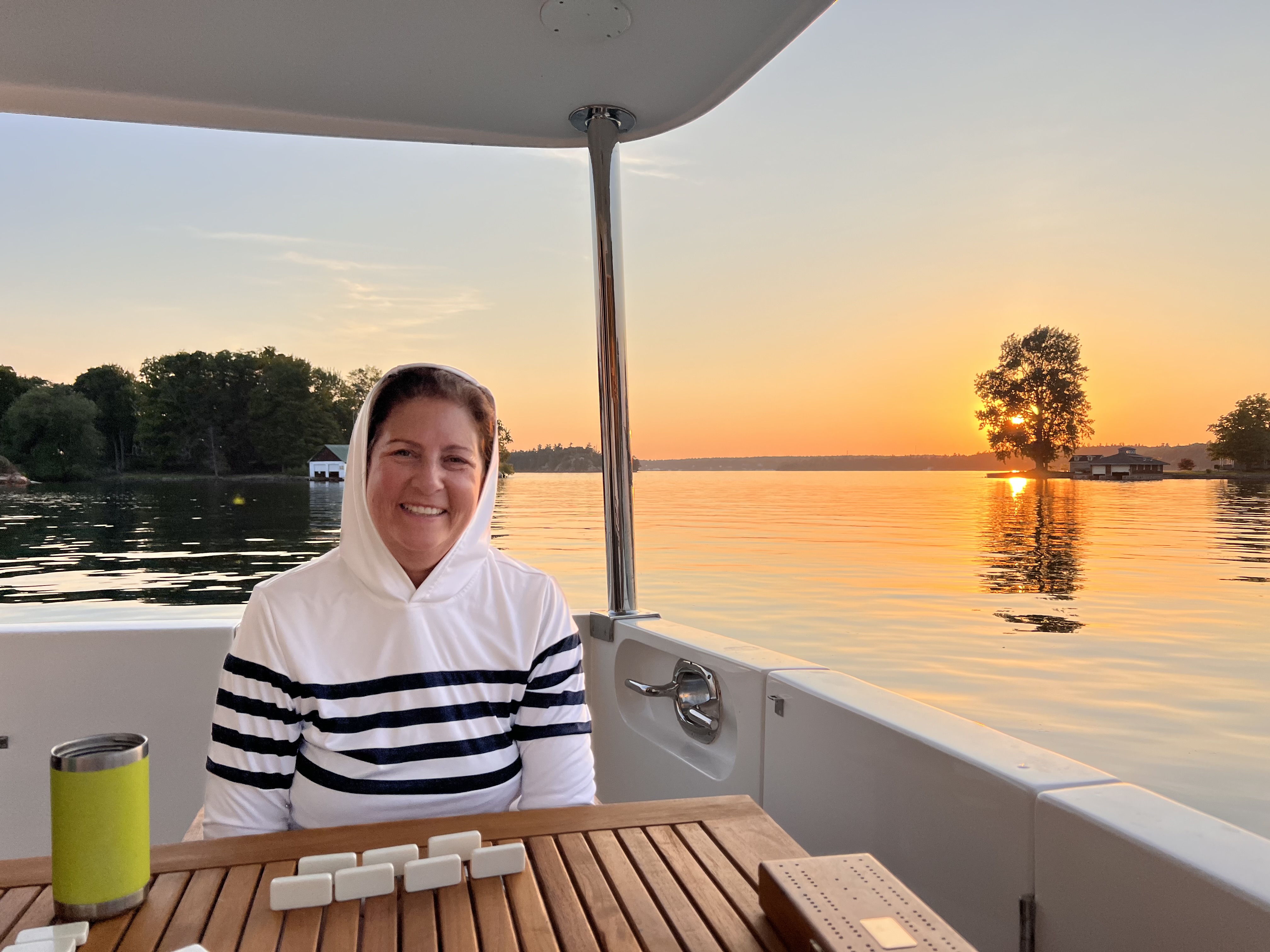
Sunset at anchor, at 1000 Islands. Post-dinner dominoes! A hood was necessary to show those mosquitos that I was in control.

LAY OF THE LAND
Lake Ontario is a border lake between the United States and Canada. The Easternmost side of Lake Ontario pours into the St. Lawrence River, also between Canada and the U.S. The St. Lawrence runs downhill (and Northeast), past Montreal, and at the 400-mile mark, Quebec City, all the way to the Atlantic Ocean. 

The head of the St. Lawrence River was a forty-mile-long region called 1000 Islands(1). I had never heard of it until a few weeks before we arrived. Yes, there were supposedly one thousand islands in the area, mostly small, and five large ones. They are populated with many waterfront homes that vacationers primarily use during the summer. 

We decided to hang out for a week and make it easy on ourselves by staying on the U.S. side. Then we would cross into Canada at a town called Kingston where we would go through customs and park the boat for a week. We took a vacation from the boat, again, and traveled via the Canadian railroad system to Montreal, Quebec City, and Ottawa. 

Our route was in red. This is the Northeast Part of Lake Ontario, if that helps you identify the area I referred to.


1000 ISLANDS


We left Oswego pretty early, I thought, but we were in the second set of boats to go through the lock (the thirty-first lock of this leg and our trip so far), the gateway to Lake Ontario. Our first take of Lake Ontario was a relief. The lake calmed down completely compared to the tremendous fetch we spied from the Fort Ontario hill three days before. Our second thought was how vast it was. We couldn't see land on the other side. And it was a lovely teal blue and noticeably clear fresh water. There was nothing brackish about this part of the trip. 

We first stopped at a 1000 Islands gateway town, Cape Vincent, which was a one-block-long town and had a free city dock.(2) We were shocked to be able to see ten feet down through the water.


We moved to the substantial gateway town, Clayton, NY, the next day. Not only was it a cute town to hang out with other Loopers and get supplies, but it also had a locally famous wooden boat museum

The homes we walked by seemed to be up to one hundred fifty years old. Most were a curious color of red brick with artistic black iron trim.(3)

We stayed at the marina for an extra night because there was much to do. 


Mike took an afternoon to join a fishing charter with some guys he met at the Clayton dock. He came home with some pike—a new taste for us. It's a good, mild-tasting fish.

There was a hum-dinger of a storm that night. I saw wind gusts of forty MPH. There was such a deluge of rain that I couldn't see the lightning strikes in the dark out our window. I only saw flashes. It reminded me that I was a long way from the Bay Area. Incidentally, Mike slept through the whole thing.


This area was famous for fast and stylish lake boats that New Yorkers used to speed to and from their tony island homes. The museum featured antique wooden racing boats and local boats owned by elite owners.

A shiny example of the exceptional antique boats in Clayton, NY. Can you imagine seeing boats like these whip around the islands in summer?


The other popular tourist stop was the Boldt "Castle" island. The small island supported an extravagant, three-story house, a family playhouse tower with a bowling alley, and a private power plant. The house was built in 1905. Rebuilding and refurbishing the structures was an ongoing process supported Boldt Castle with wedding venue fees and tourist entrance fees.  

Here was just the private power plant building from Boldt Castle. It was like something from a fairy tale. 

Our favorite stop in the 1000 Islands was at Grindstone Island. We anchored out for a night and dinghied in during the afternoon on a Friday. We quickly learned from a welcoming park ranger that there was a winery. This goal to try New York grown grapes led us on a three mile through swampy trails.

It was worth it to hike to Grindstone Winery. Helpful, hand-written signs pounded into the lush greenery, like the one next to Mike, showed us the way.


Great wine, warm hosts, and my first local delicacy--a wine slushy.(4)

Some island residents gathered at the winery for their weekly Friday night happy hour. It was fun to connect with them, comparing their community to ours at Decourcy Island. We were relieved that the apprentice winemaker was willing to give us an ATV-type ride back to the park border. We made it back to Sacagawea safe and sound with our new bottles of wine---and about twenty mosquito bites each!


We also enjoyed a couple of anchorages in between islands. These anchorages provided the first real opportunity to jump into the water right off Sacagawea's swim step. Just like in Cape Vincent, the water was clear and cool on the warm days we experienced that week. We noted that we needed some pool noodles!(5)

Mike’s drone captured this pic from above at one of our lovely anchorages. Note the posh house at the top of the pic with an arched bridge to a nearby islet. 


First swim ever off of Sacagawea in the 1000 Islands. Crystal clear water. A little cold, but doable. 


In every direction the 1000 Islands area was filled with rock islets like this one. The rocks often were striated with three colors: greenish on top, pink in the middle and blackish next to the water. Like Spumoni ice cream!

Here’s an example of one of the many, beautiful homes in the 1000 Islands:


Another notable feature of 1000 Islands are thoughtful, stylish boat houses. Here’s an example of another tasteful, large home and its boathouse:


After enough gunkholing, we puttered off to Kingston, but not without minor drama. About halfway there, Border Control stopped us. They asked us all the questions we were ready to answer for our planned customs check-in. The agents were friendly and made the stop easy. 


MONTREAL

In the morning, we left Sacagawea secured to the dock with about five lines and five fenders--just in case! We boarded Via Rail, the Canadian train system, for a three-hour ride, in comfort, to Montreal. Since we only planned to stay about twenty-four hours, we mostly stuck to touristy Vieux Montreal, the old neighborhood along the waterfront. 

Our view from the Via train as we approached I think Montreal.

At the bottom of Place Jacques Cartier, a pedestrian walkway lined with restaurants that leads downhill to the St. Lawrence River, we were impressed with a display of enlarged, turn-of-the-century black and white photos on the sides of vendor kiosks. These photos of the same area made it easy to imagine how Montrealeans used the area for a few hundred years as an open-air community center and market.


In the morning, before we departed, we decided to see how far we could walk to Montreal's hill, the Mont-Real ("royal mountain"!). Between racewalking to a subway and this uphill walk on a humid day, the excursion tuckered us out. With long days on the boat, traversing The Loop is not a great way to get your daily steps in--and we could feel it.

Climbing stairs in luscious Mount Royal Park. The greenery was so lovely. It was a weekend so it was  filled with fitness fans.

QUEBEC CITY

The journey to Quebec City(6) took another three-ish pleasant hours on a train. When we arrived after dark it was pouring rain. We decided to walk the short distance to our hotel. It turns out the hotel, and the entire historical district, were on a fairly steep hill. We survived the walk with only squishy tennis shoes and the bottom of our jeans soaked. Rain was forecast for the next two days. 

On the first morning, Mike came back to our room while I was getting ready with two new essential items: matching umbrellas printed with Canadian red maple leaves. My hero! Here in front of a random building in Quebec—all the buildings in the old city were like this one—colorful and worth a good look.

Even in the wet, the two to four-story buildings in the old city were each unique. And charming. And colorfully painted. There were flowery annuals in many window boxes and along the outdoor patio restaurants along the two tourist streets that were parallel and about four blocks apart. 

This requires a second look—this was a steep street and the window boxes were installed so that the tops were horizontal. The bottom of the boxes were parallel with the street. Cool, right?

Mike snapped this memorable view of Quebec City. Just gorgeous!

The next rainy day we spent at Quebec City's Museum of Civilization. I had never been to a museum like it. There were three main exhibits, each quite interesting. 


There was a special exhibit about gladiators in Rome. Ask me anything about gladiators now...like, did you know that different cadres of gladiators were differentiated by types of armor and weapons? And that the practice of gladiator shows petered out after a few hundred years as the quality of the gladiators decreased? 


Another richly detailed exhibit focused on the experience of aboriginal peoples of Canada. There were artifacts and descriptions of their traditional lifestyles. 

I appreciated this part of the aboriginal wing of the museum. This dramatic display showed the wide variety of snow shoes the peoples used. Their usage varied depending on the type of snow and terrain.

It was interesting yet sad to listen to recordings of people from various tribes who described how elements of their cultural identification were being lost. Other recordings described how their native cultures were evolving, just like all cultures evolve. Altogether, they demonstrated the pride and persistence of the various aboriginal peoples.


I enjoyed a History of Canada exhibit that paired descriptions of key Canadian historical dates with the chairs commonly used during the era. It also helped me to understand how the confederation of Canada was considered the inception of the country. I did not know this! 

What a unique way to learn about key dates in a country’s history. Visitors walked by a winding display of information cards marking important dates. An antique Canadian-red children’s chair associated with the era accompanied the time/card which described Canada’s inception. It worked for me.(7)  

And finally, there was an exhibit of what it meant to be a Québécois (the French term). I think it was designed for Quebec citizens to examine and perhaps strengthen what being Québécois meant to them. This reminded me that Canada is a relatively young country/democracy. 


We had two especially excellent meals (Italian and French-ish) in Quebec City. In between, we toured the fancy Fairmont Le Chateau Frontenac Hotel, the Citadelle of Quebec (which was a fort built starting in 1820 was steeped in military traditions) and the highlight: a private tour of the Governor General's mansion inside the Citadelle. We saw the luxurious formal meeting rooms and the exterior patio with an exclusive, commanding view of the St. Lawrence River. 

Me, casually strolling through the Governor General’s Mansion at the Citadelle in Quebec City. You can see the St. Lawrence River below and down a cliff to the right and the commanding view Northeast. It was a powerful place to build a Citadelle.

Mostly, we learned in a one-on-one format with our local tour guide about Canada's relationship with its sovereign, in England.(8)  

Outside of the Citadelle, which housed the Governor General’s mansion, had two of these sentries outside the gates. We watched a changing of the sentry. It was steeped in tradition and symbolism.

OTTAWA


Our last point of this trapezoidal trip was Ottawa. Mike, especially, was interested in seeing the seven "step" locks that allowed boats to move from the Ottawa River to the Rideau Canal.(9) We were there in the middle of a week, so few boats were going through. But we were impressed at the innovation of the locks and a little jealous of Loopers who could take their boats through it. Still, we were satisfied with our decision to forego the cruise there.

Mike snapped this pic of the Rideau Canal Locks from a bridge looking West. You are looking at the eight “step” locks that move boats 80 feet from Ottawa River to Rideau Canal. Also on the right is the fancy Fairmont Chateau Laurier hotel we stayed at.


Here, Mike checks out the Ottawa River, at it passes behind the government buildings and meets the Richelieu Canal. There were falls in the center and boats purposefully cruised around either side of the falls. It was a spectacular day for cloud watching as well.

The key buildings we couldn't miss in Ottawa were the national government buildings that house Parliament. These neo-gothic, behemoth buildings and towers were nothing like the neo-classical buildings in Washington D.C. We enjoyed looking at the exteriors on our sunny day in the city. 

At Parliment Hill in Ottawa. The architectural style was striking: “Gothic Revival.” Note the tall windows  with peaks and black ironwork. Totally unexpected.

In the morning, we managed to take a private tour of the temporary Parliament room (a large group canceled--we were the only ones left in the time slot). We learned about Parliament traditions related to opening ceremonies, passing bills to laws, and how they symbolically include the Sovereign. 


I found portraits of former prime ministers on the walls memorable for their intensity and relatability. Outside parliament, there was a hall filled with plaques imprinted with thousands of names: the members of each year's parliament. It was as if they were enshrined here, being accountable for Canada's choices and growth. 


TIME FOR THE TRENT-SEVERN WATERWAY


Next up: Trent-Severn Waterway. Unlike the 1000 Islands, you could say we've been anticipating the Trent-Severn Waterway for years--since we first learned of The Loop. Was it as beautiful and wonderful for boating as we had read? 


FOOTNOTES FOR FUN FACT FANS


(1) This is the home of 1000 Islands Dressing. To my surprise, I'd say the local restaurants played it down. I'm not too proud to admit that I love 1000 Islands Dressing.

(2) Many small towns along The Loop have free docks to encourage boaters to come to support the local economy. 

(3) ChatGPT says: "These homes often feature intricate detailing, such as ornate trim work, decorative brick patterns, and sometimes elements of Queen Anne or Colonial Revival styles, reflecting the prosperity and design preferences of their time."

(4) It was a port wine slushy. It's a unique blend of different ingredients, unknown to me. It's not just port wine and ice in an ICEE machine.

(5) We especially liked the fresh water swim because our shower's sump pump stopped working! We were able to order one and Mike, of course, installed it before too long. 

(6) The historic neighborhood of Quebec City is an UNESCO heritage site. All of it! Not just one building or fort.  

(7) For example, 1867, the year the British North America Act was signed, created the Dominion of Canada. Red is sort of national color for Canada; the red of the maple leaf of Canada’s flag.

(8) Canada has a constitutional democracy with a parliamentary system. They have a ceremonial head of state: the King of England. 

(9) The original motivation for building these locks was to move the British Navy during the War of 1812 (which Canada calls The War with the United States) through Upper Canada (a British colony). Ultimately, they never used it during a war. 


Feelings and Lessons Learned

Glacier Bay, Alaska. July 15, 2023. A day of good feelings, even though I’m wearing just a Mona Lisa kind of smile.  HOW AM I FEELING? Okay,...